Horsens midtby
2020 - 2023
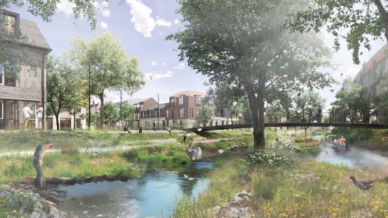
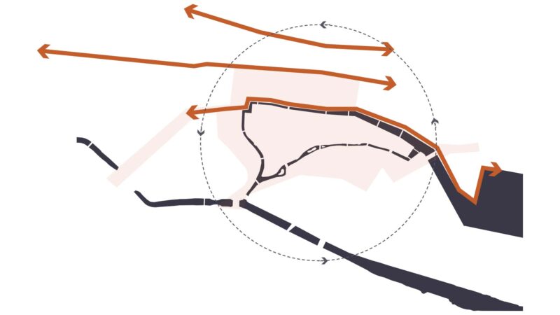
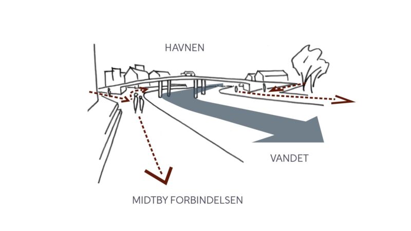
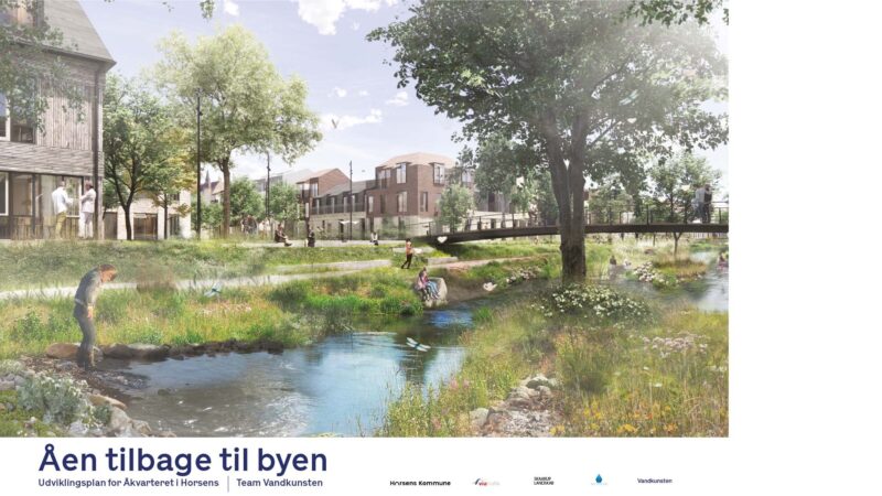
The stream back to the town
The blue loop should bring the stream back to the town in Horsens
A watercourse that better connects the city and provides climate protection for the Å neighborhood and other parts of Horsens city center, room for new urban development opportunities, and a robust road network that diverts more traffic around the city center. These are some of the elements included in Team Vandkunsten’s Development Plan for the Å neighborhood in Horsens.
Horsens was founded on the north side of Bygholm Å on the south-facing side of a hill island at the bottom of Horsens Fjord. Well into the last century, Horsens was a market town surrounded by a distinct blue-green landscape flanked by the meadows of Bygholm Å, Horsens Fjord, and Nørrestrand. It was a city closely connected to the surrounding natural environment, with the river, the river harbor, and the fjord harbor serving as the city’s front and most important connection to the outside world.
The special landscape conditions mean that the city to a large extent is still connected to valuable blue and green structures, which, however, in modern times have been pressured and reduced in favor of the city’s vigorous development in the previous century – expansion of the harbor, closure of the river harbor, development of the city both on Bygholm meadows around the river and across the hill island to the north up to Nørrestrand.
Particularly repeated regulation of the Bygholm Stream, extensive development in the low meadow areas, and filling in of the river harbor have cut off and removed the original main waterway from the medieval town.
The great potential in restoring the old medieval core’s river and harbor course is about bringing the river back to the entire city. It is about repairing an entire city’s relationship and connection to its surrounding landscape, its own origins, and the central structure around which the city originally grew and was built.
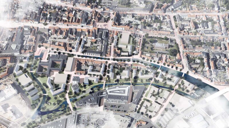
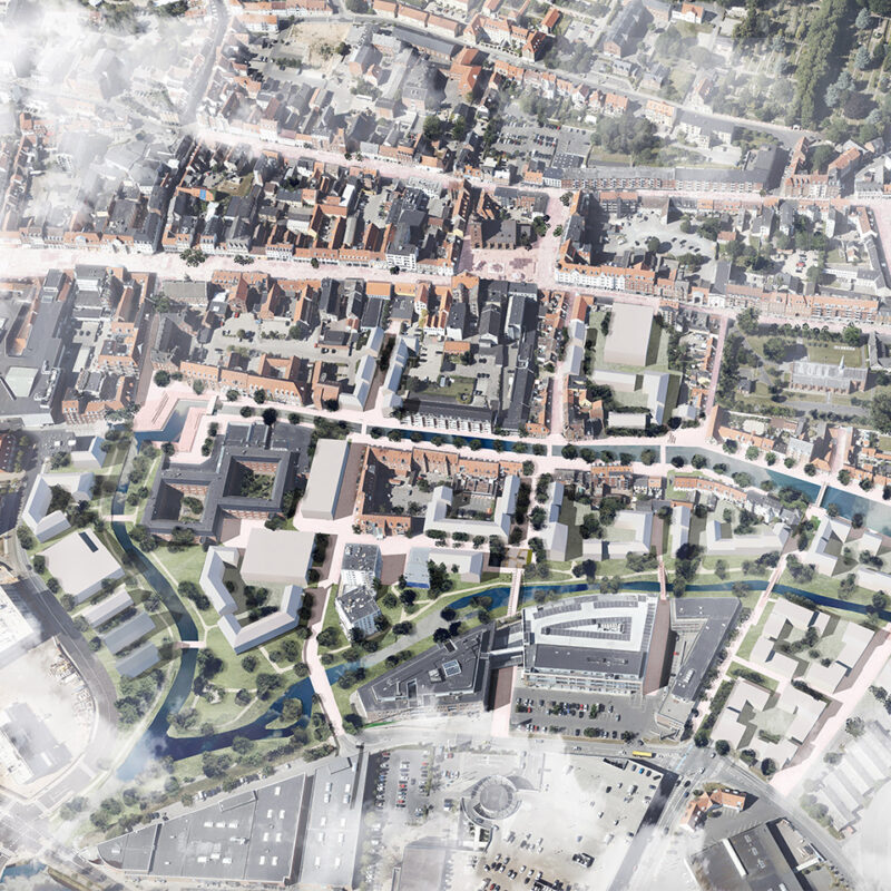
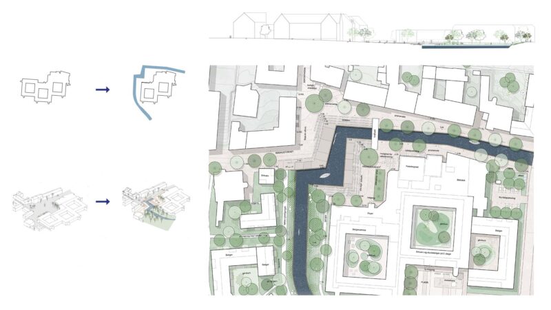
THE RIVER BACK TO THE CITY
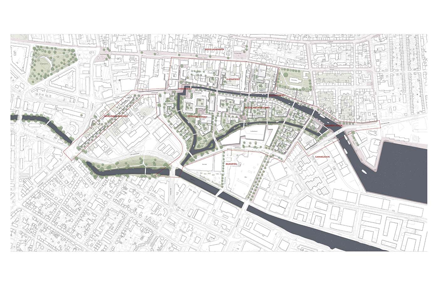
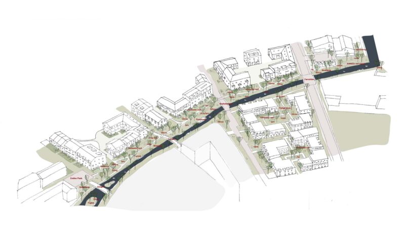
In the development plan, the Horsens city structure continues to be built upon with the three main connections: Nørregade, Søndergade, and Åboulevarden. Here, Åboulevarden is strengthened as a historic main street by restoring the river along with a new attractive promenade, which connects the city center and the harbor. The city center’s network of streets and alleys is extended through the new district and further down to the big-box stores in the south, making the Å district the transition between the city center and the big-box stores in the south.
By ensuring a better-connected and cohesive city, a foundation is created for an exciting urban life, where the harbor, city center, and nature are all integrated.
The development area includes several new urban neighborhoods, which will be developed with different identities that fit into the existing structures.
The physical plan
The overarching approach of the plan is to establish a River Loop that connects the district, transforming it from a district primarily made up of roads into a district characterized by waterways.
"With the development plan for the River District, we are now one step closer to realizing one of the city’s most ambitious urban development projects. Returning the river to the city and the opportunities it brings will take Horsens another step forward in the city’s remarkable transformation. At the same time, the plan will make Horsens’ city center greener and help climate-proof large parts of the downtown area. In short, the plan is meant to benefit the residents of Horsens, the business and cultural communities, as well as tourists, and it is intended to make Horsens city center an even better place to live and be in."
- Peter Sørensen, Mayor of Horsens Municipality
Main grip
THE THREE MAIN CONNECTIONS
The main concept supports Horsens’ historic urban structure with the three east/west-oriented main connections: Nørregade, Søndergade, and the historic river route, which are connected by a network of north/south passages. The ambition is to strengthen the southern main connection, which today constitutes Åboulevarden, by establishing a river harbor with a promenade that will serve as the link between the city and the harbor. In this way, it will once again become an important urban space in Horsens. The main connections are linked by the north/south passageways, which extend to shopping opportunities in the south, creating a cohesive city instead of isolated, inward-looking areas. The connection between the shopping areas in the south and the pedestrian street in the north will create greater cohesion in the city, which will support commerce and urban life throughout the city center.
THE RIVER BACK TO THE CITY/THE RIVER LOOP
In the future, the river will once again be the identity-defining feature for the district and the city.
The river will therefore be guided all the way around the district to ensure a strong identity for the area.
The district will thus be transformed from being dominated by roads to being characterized by water.
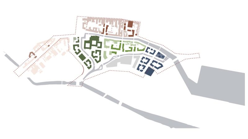
Strategy for urban development
NEW CITY DISTRICTS
The city center will consist of several new city districts, developed with different identities that fit into the existing structures. Densification occurs in interaction with the fine-meshed structure of the city center.
THE LANDING PLACE (HINGED)
A bridge will be constructed over Åhavnen and the harbor channel. The bridge allows visual contact between the harbor and the town center via the water and the promenade, becoming an important link for light traffic. The bridge will serve as a key anchor point in the city and a visually significant urban element, much more than just a road. The landing place will also be part of a neighborhood, with a promenade for staying right down to the water, as well as a public-oriented building that will become a beacon for the city.
OLD HARBOR
Along Åboulevarden, the harbor is being reestablished.
The existing buildings along Åboulevarden can reclaim their important location in the city, instead of being hidden behind parking lots and roads. The buildings, in combination with a new promenade, will experience a revival of cafes, shops, and informal meeting places along the water.
THE GREENLAND QUARTER (NIELS GYLDINGS STREET)
Niels Gyldings Street will be downgraded, in accordance with the Traffic 2030 plan, to a pathway so that car traffic is removed and a park can be established, where a natural stream meanders through. New buildings will be placed in harmony with existing ones, creating an urban area in line with the scale and rhythm of the city center.
THE TOWN HALL DISTRICT
The Town Hall is being transformed into commercial spaces, housing, a library, and citizen services, among other things. The district will get a new square, Town Hall Square. This will become a new meeting place in Horsens, where people can gather on the south- and west-facing steps down by the water. Along the district, a park has been established where the stream runs. Here, good recreational areas and attractive building plots with water views are being created. This will restore the close connection between Søndergade and the city’s water in the canal. The Town Hall District rises in height towards Ribersgade, where it meets the scale of Lilli Gyldenkilde Square.
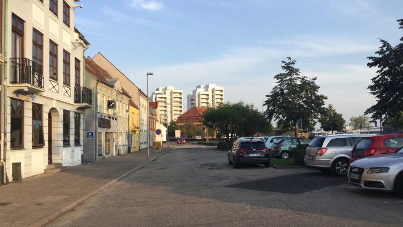
Current situation - Åboulevarden today with a view towards the harbor
It is clear here that the harbor is disconnected from the city center. The area is dominated by roads and parking lots. What was once the city’s meeting with the river has turned into a gray backside.
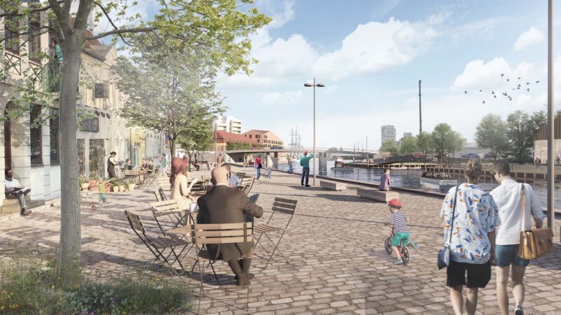
The River Back to the City - The Hinge and the Landing Stage
The city center is connected to the harbor; a future situation with the restored river harbor and the new bridge and promenade that ensure a visual and physical connection between the harbor and the city. The riverside boulevard has regained its role as an important connection in the city. On the right in the picture, the Landing Square can be seen with the public-oriented building, serving as a marker for the area.
Subarea "The Hinge" The Landing Spot
The area at Hængslet is a central place in the future development of Horsens. Here the city is connected with the harbor. This was where ships once docked at the city, and hopefully where they will do so again – hence the name Anløbspladsen (The Landing Place).
A clear prerequisite for creating a strong cohesion at Anløbspladsen, where city and water are once again connected, is good urban spaces with clear visual and physical contact with the water.
Stairs and ramps flow seamlessly down toward the new canal, creating unhindered access to the water and opportunities to stay on sunlit steps, both in the morning and evening light.
The stairs are angled so that the water opens up upon arrival from street level, and where the river harbor has its entrance, the new main traffic structure is lifted into a bridge, creating an unobstructed view between the city and the harbor.
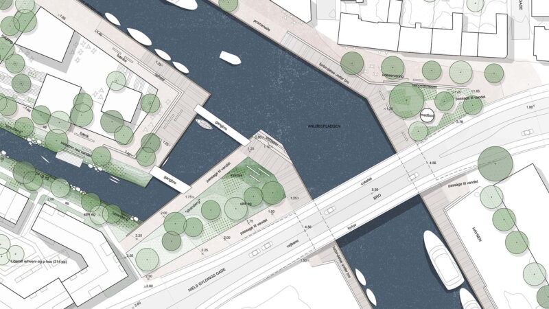
Sailboats without tall masts can freely pass under the bridge, and along the canal, space is created for a natural passage for pedestrians and cyclists. The areas near the water are designed with wooden decking and naturally connect with the already existing pathways recently established along the harbor. A route that links the Horsens city center with the harbor development. In this part of the city, several of the existing buildings are low. Quay edges and stair structures are designed to provide protection up to level 1.25 before a closure of the floodgate becomes necessary. But the design of the stair structures also takes into account that proximity to the water can be created when the water level in the fjord is low. The urban space on the northern side of the river harbor connects to the medieval city core with its fine granite-paved passages and is intended to be designed with a uniform base of Nordic granite.
The row of facades is flanked by a line of oak trees, providing a light canopy for outdoor seating along the promenade. The northern side is kept free of vehicular traffic, except for errand driving, thus creating good conditions for pedestrians and cyclists and supporting the idea of a continuous downtown connection through Horsens from the train station to the harbor.
At the tip of the quay, a special public-oriented building should be placed, which could serve as an icon for Horsens.
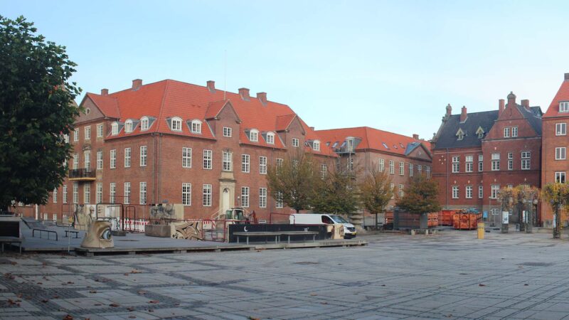
Existing situation - Town Hall Square with a view towards Rådhusgade
The square is close to the pedestrian street, but it is not an important place to spend time in the city. Today, there are temporary measures in the form of a skate or ice rink.
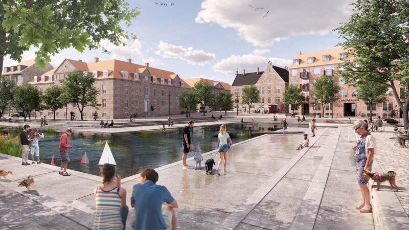
The stream back to the city - City Hall Square, a new meeting place in town
Future situation with a south-facing staircase landscape, where the stream runs through. The descent to the water will create an informal meeting place along the stream, where people can step away from the pedestrian street and sit, pause, while people walk by and canoes paddle past.
Subarea Rådhustorvet
At City Hall Square, a unique opportunity is created to "bring the river back" into the cityscape and make the water visible all the way from the pedestrian street. By transforming the City Hall and making space to channel the water around the west side of the building, a long view is created from Søndergade over the water area, which, with the blue-green structure, provides exceptional opportunities for attractive developments close to the water. Although City Hall Square is situated higher in elevation than the other stretches along Åboulevarden, it is entirely feasible to redesign the square so that the water becomes the center for public space. Through a terraced landscape, both visual and physical contact with the water is created, and the many seating steps provide ample opportunities to find a spot in the sun in the morning, at noon, and in the evening. The existing skate park on Town Hall Square will be moved to another urban nearby location, for example the new plaza on the south side of the town hall. The town hall will be converted into a library, citizen service, etc., on the ground floor, while the upper floors will be transformed into commercial spaces and apartments. It will be possible to pass through the ground floor of the building, connecting Town Hall Square with the southern plaza of the building.
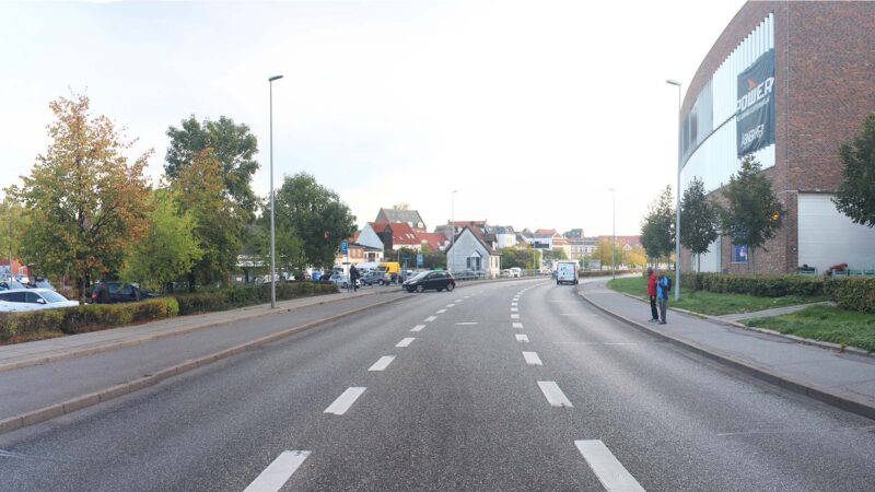
Existing situation - Niels Gyldings Gade today with a view to the east
On the left side of the picture is Emilies Plads, with the parking garage by the Sundhedshuset visible on the right. It is clear that the area is dominated by large roads and parking lots. The buildings are disconnected and messy down towards Niels Gyldings Gade.
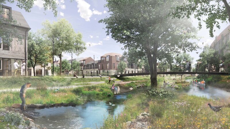
The Stream Back to the City - A green and blue park corridor
Future situation with the new park avenue where the stream runs through. The gray street has been transformed into a lush park space. Here it is both interesting to stroll and live. The new development creates a transition between the city center and the big box buildings. In the picture, Emilies Plads can be seen, with the parking garage at the Health House on the right.
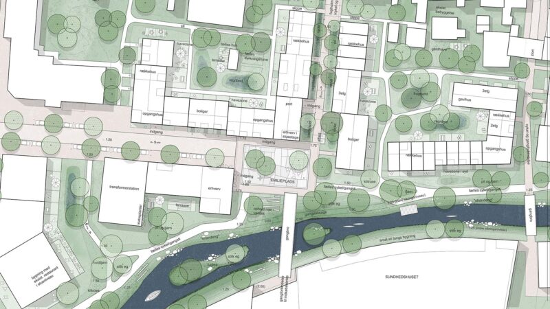
Subarea "Gröenlandskvarteret"
Niels Gyldings Street is being transformed from a gray road space into a new attractive neighborhood, where the close connection to the water and the landscape once again becomes an identity-defining factor for the area. The recreational landscape weaves itself between both new and existing buildings, thereby becoming an integrated part of the entire neighborhood.
On the sunny side of the park space, parallel to the water, paths provide access for the city’s users to the blue-green nature park, with places to stop both near the path and with detours closer to the water’s edge. If you are paddling a canoe or kayak on the water, it is also possible to dock at small wooden decks placed in selected locations. As the tide changes, the water will move up and down the gentle slopes, and the lowest-lying paths will periodically be submerged. Conversely, when the water level is low, these paths offer very direct contact with the water.
The existing development is being densified to create a transition between the block city and the big-box stores. The new development fits into the existing buildings, with rhythm, roof pitches, and setbacks and projections. This creates exciting urban spaces on a human scale.
Park strip with attractive edges
THE PARK CORRIDOR
A blue and green park corridor weaves together the city center, the new development, and the box buildings. Here, a green and lush urban space is created where the stream winds past.
Niels Gyldings Street is transformed from a gray traffic area into a new attractive urban area, where people feel inclined to live, stroll, or linger.
The width of Parkstrøget varies from about 26 meters at its narrowest point to about 50 meters at its widest. This provides ample opportunity for it to be designed as a public park space. Various green urban spaces are created, which are relatively narrow but still function as attractive public urban areas.
If the park strip becomes too wide, it could become a barrier between big-box stores and the urban densification at Emilies Plads. The narrow distance allows for an interaction between the two worlds.
THE EDGE ZONE
From the buildings, a 1.5-3 meter garden zone is established where residents can step out and enjoy the proximity to the park and water. A low hedge is planted to clearly define what is private and public. A green intermediate area creates a separation between the public path and the private garden.
By adding a garden zone to the park, the park also feels safer during the night and evening hours, as there are ‘more eyes’ on the park.
The garden area is south-facing with good sun exposure, and the development offers attractive views of the water, which also makes the area particularly appealing.
Product: Development Plan - Åen tilbage til byen
The development plan was adopted by Horsens City Council in May 2023.
Read the development plan here.
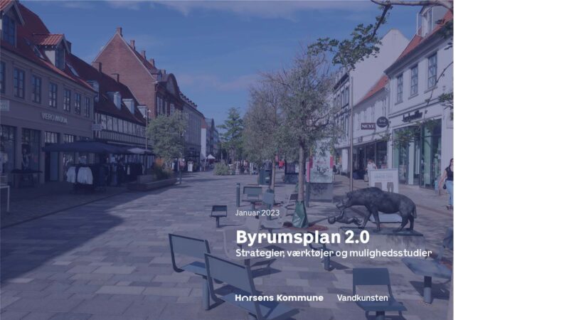
Product: Byrumsplan 2.0 - Strategier, værktøjer og mulighedsstudier
Byrumsplan 2.0 was adopted by Horsens City Council in April 2023.
is prepared based on the Horsens Urban Space Plan from 2008 and serves as a working tool for the later initiation of measures in the city’s public spaces. Urban Space Plan 2.0 addresses both private and municipal areas, which have the potential to contribute in the future with significant experiential and architectural value for the citizens of Horsens Municipality. The principles from the Development Plan for the Åkvarteret district are incorporated into the urban space plan. This means that all strategies take into account Horsens Municipality’s visions for the future area. The urban space plan brings adopted policies and strategies into play in a single comprehensive tool for the development of the city’s public spaces, including the Architecture Policy, the Parking Strategy, Traffic Plan 2030, the Biodiversity Strategy, the Strategy for Circular Economy, and the Climate Plan. Through analyses, toolkits, strategic approaches, and feasibility studies from selected areas in the city center, the opportunities that currently exist in Horsens city center are made visible. The four sub-areas represent very different types of urban spaces found in Horsens city center.
The urban space plan consists of three parts;
– Background, – Strategies and keys, and – Feasibility studies.
The urban space plan aims to highlight the current challenges with the public spaces in Horsens city center, identify new urban spaces (squares, streets, courtyards, parks, etc.) that should be focused on in the future. The identification is based on analyses, four strategies, and a set of tools, facilitated by a ‘key’ that emphasizes the importance of freeing areas for redevelopment, focusing on Horsens Municipality’s strategies and policies that influence how the city’s spaces are transformed, and illustrating examples of how the four strategies can serve as a basis for transforming urban spaces in Horsens city center. The examples are presented as four feasibility studies.
Read the urban space plan here.
Project Facts
Building Data
Project Name: Development Plan for the Åkvarteret in Horsens
Category:Housing, Landscape, Planning
Client: Horsens Kommune
Location: Horsens midtby
Date: 2020 - 2023
Status: Afsluttet
The Task
Program: Parallelopdrag, Udviklingsplan, Byrumskatalog
Activity: Strategisk byudvikling
Job Type: Planlægning
Contact: Jan Albrechtsen, jal@vandkunst.dk
Contact Group:Maria Ramild Crammond, Sam Coolidge, Olivia Thomsen
Consultant Team
Architect: Vandkunsten
Landscape: Skaarup Landskab
Engineer: Via Trafik, Bactocon